About Hungary
2025.02.16. 2025-09-04 10:18About Hungary
Things to know about Kecskemét
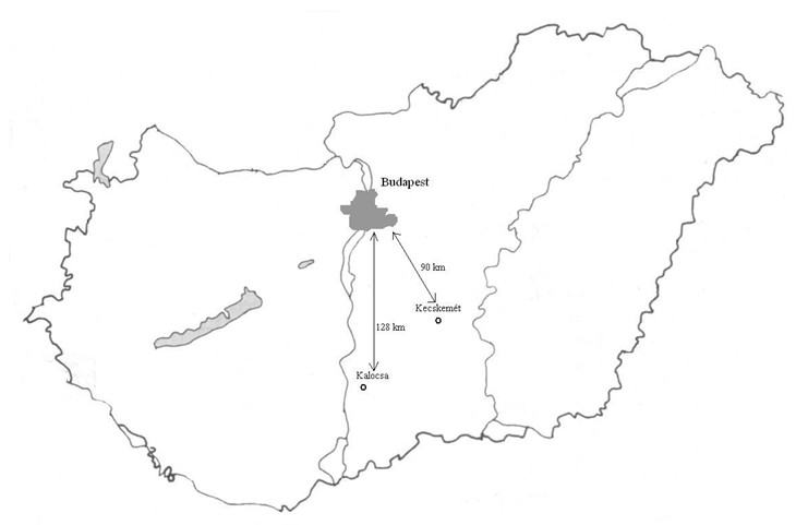
Kecskemét is the principal town of Bács-Kiskun County and the largest settlement in the Danube-Tisza Interfluves. Located approximately 70 km northeast of Budapest, it is easily reachable by car from the capital, taking about an hour via the M5 motorway.
This town exemplifies the character of the Hungarian Great Plain and serves as a significant cultural and economic hub for both the region and the entire country. Its importance is underscored by the establishment of a Mercedes assembly factory in Kecskemét in 2011.
Things to know about Kalocsa
Kalocsa is a quintessential small town in Bács-Kiskun County, situated about 100 km south of Budapest along the banks of the Danube River, Hungary’s largest river. Predominantly agricultural, Kalocsa is renowned for its famous red paprika, a staple ingredient in Hungarian cuisine.
The town is also celebrated for its folk embroidery and national costumes, which are deeply rooted in Hungarian folk traditions, music, and dance. Kalocsa serves as both an archbishopric and a cultural center.

 With a history spanning over a thousand years, Kalocsa is located in the western part of Bács-Kiskun County, approximately 120 km from Budapest. It has a population of around 20,000 and is a regional center for commerce, culture, and education.
Kalocsa’s fame can be attributed to three key aspects over the past millennium: its status as a cathedral town since 1002, the cultivation of paprika in the region since the early 18th century, and the global recognition of its folk art that emerged in the 19th century.
Kalocsa’s history is intertwined with the establishment of Hungarian statehood, as the first king founded church districts in the area, leading to the town being awarded archbishopric status, making it the second center for the Hungarian Catholic Church after Esztergom.
Since the 1700s, Kalocsa and its surrounding region have been vital in paprika production. Initially grown for personal consumption, local farmers began cultivating it for national distribution and, by the early 20th century, for export. The invention of the heat-free paprika around 1920 at a Kalocsa research institute further propelled its global popularity.
The „Kalocsa folk art” characterized by vibrant patterns of natural motifs, evolved from peasant art in the late 19th century. While its roots trace back to earlier traditions, its distinctive color palette emerged in the early 20th century, appearing on wood carvings, pottery, folk wall paintings, and textiles. Kalocsa’s folk art has gained worldwide recognition through embroidery, china ware, and folk wall painting.
